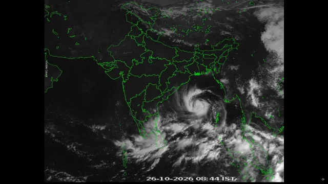
Cyclone Arnab’s Unusually Swift Rise; How Much Did El Niño Contribute?
Cylone Arnab News: Cyclone Arnab’s sudden rise leaves models scrambling, turning the spotlight onto 2026’s record El Niño warming in the Pacific.
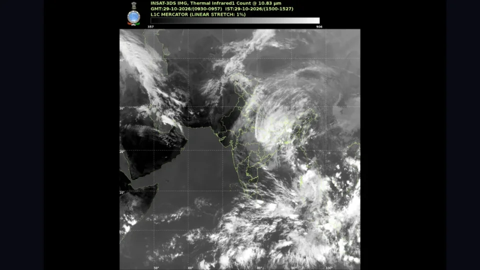
Cylone Arnab News: While ‘very severe’ cyclone Arnab is slowly dying down and is expected to weaken over North Chhattisgarh and adjoining northwest Odisha, it continues to influence weather and sea activities across central and eastern India. The cyclone made landfall on the Andhra Pradesh coast early on October 28, with winds of 125–135 kmph, gusting to 140 kmph. The storm’s unusually fast movement and rapid intensification have also drawn attention to El Niño, the phenomenon of abnormal warming of surface waters in the equatorial and central Pacific, which is intensifying rapidly in 2026 and may have helped make Arnab stronger and faster.
More than 1.8 lakh people were evacuated in Andhra Pradesh and Odisha before landfall, according to The Indian Express, while the World Meteorological Organization (WMO) has warned of intense cyclones affecting Asia during this El Niño year.
While Arnab is weakening, its remnants continued to unleash exceptional rainfall on Thursday in Odisha’s Ganjam district, coastal Andhra Pradesh and Yanam, Gangetic West Bengal, Jharkhand, Chhattisgarh and Telangana.
Realised Weather During the Past 24 Hours Ending at 08:30 IST on 29th October 2026: ❖Exceptionally Heavy Rainfall has been recorded over Ganjam (Odisha) {54.6 cm} ❖Extremely Heavy rainfall has been recorded over Coastal Andhra Pradesh & Yanam (21-30cm). ❖Heavy Rainfall has been recorded over Gangetic West Bengal, Jharkhand, Chhattisgarh and Telangana (7-11 cm) #ExtremelyHeavyRainfall #Rainfall #RainfallinOdisha #RainfallinYanam
— India Meteorological Department (@Indiametdept) October 29, 2026
Another Low-Pressure Area
A fresh tropical disturbance has emerged over the South Andaman Sea and adjoining region, forming a low-pressure area at 05:30 AM IST on October 29, 2026, under the influence of a preceding upper-air cyclonic circulation. According to the India Meteorological Department (IMD), the system is tracking west-northwestwards and is expected to intensify into a well-marked low-pressure area over the South Andaman Sea and the Andaman and Nicobar Islands within the next 24 hours.
As it maintains its west-northwestward trajectory across the Bay of Bengal, the disturbance is forecast to concentrate further into a depression over the southeast Bay of Bengal, adjacent to the Andaman and Nicobar Islands and the Andaman Sea, during the subsequent 24-hour period.
The El Niño Connection to Arnab
El Niño is a climate pattern marked by warmer-than-normal sea-surface temperatures in parts of the equatorial Pacific, emerging roughly every two to seven years, according to US space agency NASA (National Aeronautics and Space Administration). It can alter global rainfall, winds and the distribution of tropical cyclones, floods and fires.
We're headed for an El Niño that is — quite literally — off the charts. WMO's Global Seasonal Climate Update shows that El Niño is forecast to exceed the scale of global monitoring charts. Its impacts will be felt well into 2027. Read the full update: https://t.co/TNAzqhUN1h https://t.co/wepfQM8Z7z
— World Meteorological Organization (@WMO) October 22, 2026
For India’s east coast, the effect is particularly significant. During El Niño years, cyclones forming in the Bay of Bengal tend to develop closer to the equator and are more likely to move towards Andhra Pradesh and Tamil Nadu than Odisha and West Bengal, IMD chief Mrutyunjay Mohapatra had earlier explained, The Indian Express reported. The 2014 El Niño year saw Cyclone Hudhud strike the Andhra Pradesh coast in a similar pattern.
Warm oceans act as fuel. From July to September, sea-surface temperatures in the Pacific’s Niño 3.4 region, the benchmark for measuring El Niño, were 2 to 2.8 degrees Celsius above normal, according to NASA. Ocean temperatures of 26 degrees Celsius or above, at depths of 50–100 metres, are conducive to cyclone formation, and warm seas can contribute to rapid intensification.
El Niño’s warmer waters could be adding energy to the wider system, while a compact core, low vertical wind shear, moist air and efficient heat release helped Arnab intensify quickly, according to a report by India Today. However, the report also noted that several forecasting models reportedly failed to anticipate the full extent of the storm’s strengthening, and official estimates appeared to underestimate its intensity until only hours before landfall, leaving a narrower window to assess the threat.
Briefly about ‘Arnab’
Arnab began as a low-pressure system in the southeast Bay of Bengal on October 23 and intensified into a cyclone by October 26, before strengthening to its highest “very severe” category within a single day, according to IMD data. NASA said the storm emerged in the Bay of Bengal on October 25, a late start for a basin that typically produces named cyclones in April or May, and recorded sustained winds of about 140 kmph on October 26-27; at landfall between Bapatla and Visakhapatnam, NASA classified it as a very severe cyclonic storm, comparable to a Category 1 hurricane on the Saffir-Simpson scale.
Damage and official response
The cyclone uprooted trees and power poles, caused power outages, inundated crops and homes, disrupted transport and limited fishing operations, according to news reports cited by NASA. Heavy rainfall battered coastal Andhra Pradesh and Odisha from Tuesday, with Visakhapatnam recording 217 mm, Kalingapatnam 147 mm, Tuni 123 mm, Kakinada 118 mm, Machilipatnam 115 mm and Gopalpur 94 mm, according to IMD figures.
Several parts of Odisha remained on red alert, while Andhra Pradesh was under a yellow alert. The IMD issued orange, yellow and even green alerts across Chhattisgarh on Wednesday. In Odisha, Chief Minister Mohan Charan Majhi said 2,245 pregnant women were shifted to healthcare institutions ahead of the cyclone and 931 babies were delivered during the period. All mothers and babies were reported to be doing well, according to PTI.
What Comes Next
Arnab weakened into a depression over south Chhattisgarh and adjoining south Odisha on Thursday, and the IMD expects it to weaken further into a well-marked low-pressure area by Thursday evening. As its remnants recurve northwards, very heavy rainfall, measuring 115–204 mm in 24 hours, is forecast over parts of Telangana, Chhattisgarh, Jharkhand, Bihar, Gangetic West Bengal, eastern Madhya Pradesh and eastern Uttar Pradesh over the next two days.
Weather Warning for 29 October 2026! #WeatherUpdate #RainfallForecast #IndiaWeather #HeavyRainfall #VeryHeavyRainfall #LightningStorm #WeatherWarnings @moesgoi @airnewsalerts @DDNational @ndmaindia @ICRER_MHA https://t.co/JBbUYvc1yC
— India Meteorological Department (@Indiametdept)
In West Bengal, the IMD has forecast heavy rain in South 24 Parganas, Purba and Paschim Medinipur, Jhargram, Bankura and Purulia until Friday, with heavy rain also expected in the sub-Himalayan districts of Darjeeling, Kalimpong, Jalpaiguri and Alipurduar until Saturday morning. Sagar Island recorded 81.8 mm of rain in the 24 hours up to 8:30 am on Thursday, the highest in the state, PTI reported.
A fresh low-pressure area has also formed over the South Andaman Sea, and the IMD expects it to intensify into a depression over the southwest Bay of Bengal as it moves west-northwestwards, PTI reported. Even as Arnab weakens, authorities remain alert: India Today noted that weakening storms can still bring destructive winds, torrential rain, coastal flooding and dangerous inland inundation.